Places named Maxwell
This page is intended to be the home of descriptions of places named Maxwell. I think most of us are fairly impressed to find a place named after us. I have been to several Maxwell places in my time. I do of course live in the same county as Maxwelltown which although sounds as though it is as old as our name it was in fact only named as such in the nineteenth century having passed through history happily known as Brigend of Dumfries i.e. "the other end of the bridge coming out of Dumfries". I have not yet composed or written this article mainly because I do not know anything about Maxwell California or Maxwelton in Queensland and any other Maxwells dotted around the world. Therefore could any person familiar with these far-flung and exotic places write and tell me about them so that I can fill in this empty page.....
|
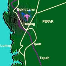
Maxwell Hill Malaysia's oldest and smallest hill resort is Maxwell Hill or Bukit Larut, approximately 9 km from Taiping in Perak. It is approximately 1,035 m above sea level and is blessed with a cool temperature and beautiful natural surroundings. Visitors have often remarked upon its striking resemblance to summers in Switzerland. A 10-minute drive up steep hairpin bends brings you to the summit. The narrow winding road was reportedly built shortly after World War II and was completed in 1948. It remains much the same today and provides a thrilling drive through thickly wooded terrain with occasional glimpses of a swift-flowing mountain stream. Why it is named Maxwell Hill, I do not know..... |
 |
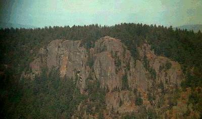 |
Mount Maxwell Mount Maxwell is on Salt Spring Island, British Columbia, Canada. It is 1975 ft or 602 m high and it is a Provincial Park area. It looks a pretty rugged lump of rock in this photograph I found on the web. There is very little else to say about it. A liberty ship (MV Mount Maxwell Park) was named after it during the second world war. I've never been there. I do not know why it is named Mount Maxwell! |
The Maxwell Land Grant
On
the 8th January 1841, Charles Beaubien and Guadalupe Miranda, two Mexican
citizens living in Taos along with a silent partner, Charles Bent, petitioned
the Mexican government for a large grant of land along the foothills of the
Sangre de Cristo Mountains neighbouring the Santa Fe Trail. They wanted to
raise sugar beets and "establish manufactories of cotton and wool, and
raising stock of every description." The petition was for a piece of
choice land straddling the border between New Mexico and Colorardo, covering
2,680 square miles that amounted to 1,714,765 acres!
Three days later Governor Manual Armijo approved the request. In
February 1843, having done little more than "pull up weeds" Beaubien
and Miranda applied for title to the grant and were promised that it was
forthcoming. The Treaty of Guadalupe Hidalgo was signed in 1848 and the
government of the United States formally recognized all legitimate Mexican
land grants. Beaubien intended to pass control of the Grant down to his son,
Narcisco, but after renegades killed Narcisco during the Taos Revolt of 1847,
management and ultimately ownership of the Grant passed to his son-in-law, the
former trapper and explorer Lucien Bonaparte Maxwell.
Charles
Beaubien died on 10th February 1864, and Beaubien's partner, Guadalupe
Miranda, had fled south after the Taos Revolt whilst Charles Bent had been
killed at Taos along with Beaubiens son. Within two years of his
father-in-law's death, Maxwell had managed to purchase additional deeds to
that part of the Grant he had not inherited. The towns of Cimarron and Rayado
had been established by Maxwell in the 1850s and Fort Union had been built
to protect travellers along the Santa Fe trail. In the early years the Grant
had been plagued by Indian war parties who attacked travellers and settlers
alike but by the 1860s the Indians had been suppressed and now camped on
the outskirts of the townships and relied on the Indian agencies for their
survival.
In October of 1866, three men travelled to Moreno Valley and began to investigate a promising stream flowing down from Baldy Mountain. Gold was discovered and by the Spring of the following year the rush was on. Settlements like Baldy Town, Elizabethtown and Virginia City sprouted like mushrooms. Some prospectors made over $1,000 a day. Maxwell became rich by leasing out land to the miners. When Colfax became a county in 1869, Elizabethtown was made the County Seat and Maxwell was elected probate judge. Maxwell was also selling land leases through out the Grant to farmers and reputedly gave land to some friends, sometimes with no more than a handshake to settle the deal, these casual arrangement would come back to haunt these settlers in later years. By 1869, Maxwell was loosing control of the situation within the Grant. Family and friends were employed as agents and managers, but ultimately Maxwell had the job of try to make everything work peacefully which he could not do.
Exasperated by the situation, on 28th January 1870, Maxwell sold the Land Grant with the exception of his home at Cimarron and a thousand acres surrounding it, for $1,350,000.00. The purchaser was a syndicate headed by a Jerome B. Chaffee, Charles Holly, and George Chilcott. Maxwell had accepted a $10,000 option to buy from Chaffee. The Chaffee group immediately sold the Grant to an English syndicate for the same price of $1,350,000. Maxwell then received $660,000 at the completion of the resale and shortly after sold the Cimarron property for an additional $125,000. Although the Territorial Secretary approved the transaction, the new owners of the now so-called Maxwell Land Grant had years of legal battles over ownership ahead of them. Backed by the politicians and financiers known as the Santa Fe Ring they tried to evict the squatters, settlers, miners and small ranchers. There was much bloodshed around the rights of ownership and the claims to pieces of property on the Grant. The unrest became known as, the Colfax County War, with litigations, shootings and riots plaguing the area until the 20th century.
The Maxwell Land Grant was the single largest tract of land in the private ownership of one person in the history of the United States. It is mostly remembered for the problems that arose after it was sold rather then for the six years that it was Lucien Maxwells private kingdom. Maxwells name lives on in the small township of Maxwell, the Maxwell Natural Wildlife Reserve and in the other towns like Cimarron and Rayado that he founded.
Maxwell Montes
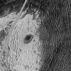
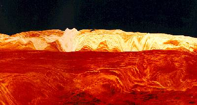
On the Maxwell World Web site we go out of this world to bring you the very best bits of Maxwell in the Universe. So right out there on Venus is the Maxwell Montes. Naturally being the highest mountain on Venus they needed a great name. The mountain is in the Ishtar Terra range in the northern hemisphere and is thought to being an area which still retains Venusian water, albeit frozen. I have never be there, but I am assured the views are wonderful. I understand it was named after James Clerk Maxwell, but I suspect a lot of things out in space are going to be named after him in the years to come. I have read that Maxwell Montes is 11 km high and also that it is 17 km high. Which ever, it is either big or enormous. The photo by Magellan on the left is of Maxwell and the Cleopatra crater! and the photo on the right is a radar simulation of the mountain range with Maxwell Montes just left of center.
 |
 |